Hiking Dude Blog
2025 2024 2023 2022 2021 2020 2019 2018 2017 2016 2015 2014
2013 - Dec Oct Sep Aug Jul Jun Feb
2012 2011
06/25/2013
My Little Friend
 One of the Leave No Trace principles to minimize impact is Travel and Camp on Durable Surfaces. One of the ways to interpret this is to stay on trails when hiking.
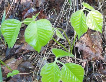
As you can see, that is a good idea not only to minimize impact but also to keep safe. I found his little friend of mine along the trail this morning while doing my daily hike. With the three cute little leafs, all shiny and green, he looks harmless enough. No prickly needles or scratchy thorns, but he can cause plenty of trouble if you touch him.
It's the urushiol in the poison ivy that causes skin irritation, more on some people than on others. By staying on the trail, keeping your eyes open, and paying attention to your surroundings, avoiding poison ivy isn't too difficult. When you go off trail, chances of running into it go way up. Actually, just off the trail is one of the best places for poison ivy to grow since it likes wood edges just like the side of a trail, road, or meadow.
It takes only a few minutes after contact with poison ivy for the urushiol to absorb into the skin, but it may take many hours for the itching, rash, and blisters to develop. Immediately washing off the contact area with soap and water is your best bet. Clothes that have contacted poison ivy should also be washed.
Poison Oak and Poison Sumac are also urushiol-producers and cause similar problems as poison ivy.
Burning poison ivy is especially dangerous because inhaling the smoke can effect your lungs.
Hike On Safely
02/26/2013
Food Hanging
 It's not so bad when just car camping, but if your food is lost while deep in the backcountry, you can be in a world of hurt. With a couple days hiking between you and the nearest trailhead, running out of food probably won't kill you, but it's a big step in that direction.
What? How can someone LOSE their food? - you might ask.
- Water - Rain and crackers don't mix well. Dropping a food bag into a lake or stream can ruin unprotected items. Fortunately, this is easy and light to prevent. Repackage everything into zip-loc bags. This reduces packaging weight and keeps everything safe from moisture. Putting multiple small bags into a larger 2.5 gallon zip-loc increases the protection.
- Dirt - When you drop your tortilla with peanut butter on it, you already know which side will hit the ground! You can blow dirt off many items, but not all. Being careful when opening packages, passing bowls, and stirring pots is the best guard against dropping and spilling food. No one's going to want that ramen after you tip the cookpot over, are they?
There's not much concern about dirt getting into food in transit, but spilling food is a common problem. - Stupidity - The food is forgotten in the car, along the trail, or at the previous campsite. By just not paying attention and double-checking yourself, you can forget your food. Yes, I have seen it happen!
- Animals - Critters are opportunists. Anything that smells interesting gets investigated. And, they can find the smallest bits hidden far out of sight. The most common stealers are mice, chipmunks, raccoons, other rodents and birds. Bears generally stay away from people, unless they've been habituated - learned to associate people with easy food. In those popular locations with habituated bears, special regulations are in place for visitors which often includes use of bear-proof cannisters.
Whether it's bears or mini-bears (rodents) that are the concern, protecting food is handled in a similar manner. Storing it in a smell-resistant bag and hanging it out of reach keeps it safe.
On the Arizona Trail, there were often no trees to hang my food. But, bears weren't a concern either. There are wire mesh food bags available that mini-bears can't chew through, like OutSak.
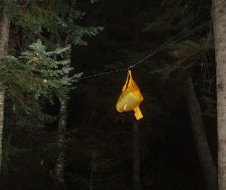
For those times when you need to hang, I've found the PCT Method to be the best if there are large trees around. Along the Superior Hiking Trail, I could often only find smaller trees and came up with my own way of hanging so the food is high enough and away from the tree.
- Throw rope with carabiner on end over high branch.
- Clip food bag to carabiner. Lift carabiner and food bag as high up the rope as possible and loop rope through carabiner so it doesn't slide.Walk the other end of the rope away from the tree to move the bag out from the tree.
- Tie rope to another tree as high up as I can reach.
This puts the food bag well over 10 feet up since I can reach up 8 feet. Well, at least I didn't lose any food!
But, here's something new and interesting...
A couple guys at University of Wisconsin in Stout, WI have designed a new product for hanging food bags. It's supposed to be simple to use and secure from pesky food stealers.
They made this video demonstrating how to use it. Unforatunately, there aren't any close-ups of the device or explanation on how it works.
So, take a look and let us all know what you think - innovation or not?
Hike On
02/19/2013
Why Hike the AT?

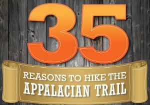
 Click the image to view a fun map image of the Appalachian Trail with 35 reasons to hike the trail.
And, here's a few more oddities, tidbits, and fun about the Appalachian Trail:
- Over 250 shelters cover the trail with spots to spend the night - one about every 10 miles.
- A thru-hike costs $3,500 to $5,500 - depending on how much time is spent in towns.
- A bit over 700 people reported hiking the entire AT in 2011.
- Over 12,000 people have reported hiking the entire AT.
- Max Patch Bald is considered by many to have the best views of any spot on the trail.
- Trail Magic is common and a wonderful boost to hikers.
- Roan High Knob is the highest shelter on the trail at 6,285 feet.
- Clingman's Dome is the highest point on the trail at almost 6,700 feet.
- Bear Mountain Bridge is the low point of the trail at 124 feet.
- Around 160,000 white blazes mark the trail.
- Spy Rock is a Confederate army lookout.
- Pennsylvania is called Rocksylvania due to the roughness of the AT through that state.
- Most thru-hikers pick up trail names at some point. It's easier to remember Hiking Dude than Bob.
- 100 Mile Wilderness in Maine is the most remote section of the AT.
- The Appalachian Trail is 1/3 of the Triple Crown which includes the Pacific Crest Trail and Continental Divide Trail.
Can you think of any other reason to hike 2,200 miles?
Hike On
If that image can't be found see alternate image.
02/18/2013
Swami's Hike
Swami, from Australia, hiked around the USA over the past 18 months - completing the AT, PCT, CDT, AZT, SHT, and some other trails. Just an amazing trip and person.
I met Swami heading southbound on the Arizona Trail while I was heading north. I didn't realize then what sort of wild hike he was on. See his website at TheHikingLife.com.
Here's an Australian news story about his adventure:
I met Swami heading southbound on the Arizona Trail while I was heading north. I didn't realize then what sort of wild hike he was on. See his website at TheHikingLife.com.
Here's an Australian news story about his adventure:
Leave Comment
Posted: 02/18/2013
Posted: 02/18/2013
02/13/2013
Animal Tracks

 What do fresh snow, mud, and dirt have in common?
They're perfect for finding animal tracks on your next hike!
But, once you've found the tracks, you need to figure out what animal made them. That can be a challenge, especially for people just starting their outdoors adventures.
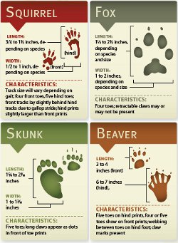
These Animal Track ID Cards are great for identifying 16 animals you might find on your travels, from the tiny mouse to the huge bear. It's a great resource to print and keep in your pocket for quick reference.
What should you do if a young one asks you, 'Hey, what's that print?'
Hand him the sheet so he can figure it out himself instead of impressing him with your infinite wisdom and simply saying, 'Oh, that's a wolf.' Discovery is the best teacher!
Hike On
(If that link above doesn't work, see the backup.)
.
Leave Comment
Posted: 02/13/2013
Posted: 02/13/2013
Older Posts Newer Posts
Find more Hiking Resources at www.HikingDude.com


Follow Me
Recent Comments