

Hiking Dude Blog
2025 - Aug Jul
2024 2023 2022 2021 2020 2019 2018 2017 2016 2015 2014 2013 2012 2011
11/27/2016
Frosty Walk
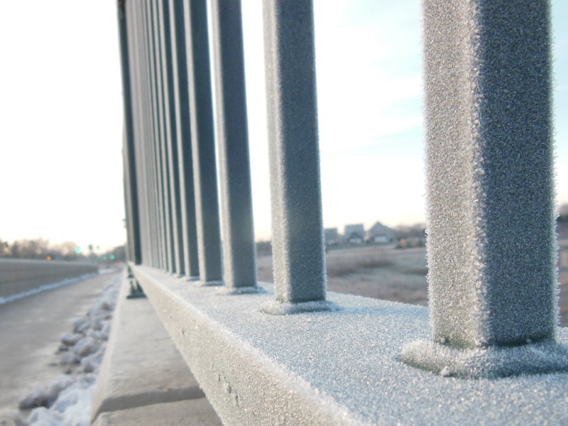

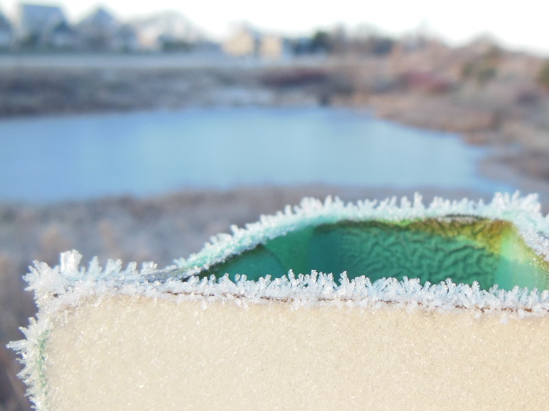
Bundling up a bit more every morning as the temps slowly fall and the frost gets thicker. With the clear, crisp, beautiful days, it all melts away fast but comes back each morning.
It's much more quiet on the walking trails these days as the summer runners and bikers are calling it quits for the winter. That's fine - more opportunity to visit with all the critters along the way that haven't migrated or set up their winter lair to wait out the cold months.
This stretch between Thanksgiving and Christmas is a very important time to keep up with my morning walks - try to keep the winter fat from building up and keep the blood from freezing in the veins. :-) Actually, I'm really just hoping for some big snow soon so we can do some cross country skiing this winter. It's historically a 50/50 chance of having a white winter here, so we'll see.
11/28/2016
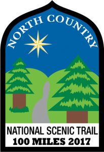
NCT 100 Challenge
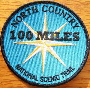
Check it out - I got my North Country '100 Miles' patch! Anyone can get this, and the accompanying certificate, by hiking any 100 miles of the North Country National Scenic Trail before January 1, 2017. So, you've got a month left to get 'er done.
You can walk the same mile of trail back and forth and back and forth and ..., or just start hiking and don't stop until you've gone at least 100 miles. That's not hard since the NCT is 4,600 miles long from the middle of North Dakota to the New York/Vermont border. I did my 100 miles on the Superior Hiking Trail, completing 85 miles with a friend on a 5-day backpacking trip and then the other 15 miles on pieces of the trail through Duluth. The Superior Hiking Trail, Border Route Trail, and Kekekabic Trail are all part of the NCT in Minnesota.
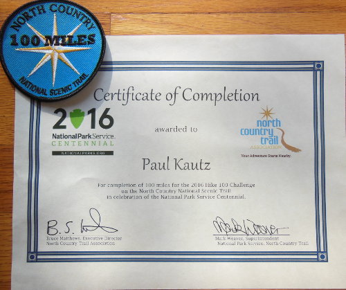
Snowshoeing, running, and walking are all legal ways to do your 100 miles. Weekend hikes in December or a longer trip after Christmas will get you through the challenge. You can read more details at this NCT page.
You might not have time to do all 100 miles at this point, but if you've already hiked some, push it to finish it! A couple weekends could do it.
You might even win some very cool gear - no, wait, I'm winning that!
#Hike100NCT
Leave Comment
Posted: 11/28/2016
Posted: 11/28/2016
12/13/2016
My Trail
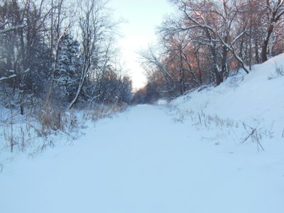 Coldest day of winter so far. Six miles walking on the trail this morning and I didn't see anyone else. Not even a rabbit, squirrel, turkey, or deer. I guess when it's -10F it's My Trail and I don't have to share.
Five inches of fresh, fluffy snow and I got to make the first tracks through it - pretty fun. But, it was a bit cold out.
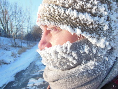 Frost builds up everywhere when you're exhaling warm, moist air for an hour and a half. A scarf really, really helps since it traps warm air around your face and heats the air a bit before it gets sucked into your lungs.
Fortunately, there was no wind today so it could have been a lot worse. I normally wear sunglasses since the snow is so bright once the sun comes up, but when it's this cold they fog up so bad I can't see at all.
Leave Comment
Posted: 12/13/2016
Posted: 12/13/2016
12/14/2016
Support the Smokys

You heard about the big fire that swept through the Gatlinburg, TN area and affected the Appalachian Trail this past month, right? If you're feeling like helping out, here's a way that might sit well with you.
Lodge will donate $15 from each sale of this $30 limited-edition 10.25 inch Great Smoky Mountains 2016 skillet to the Dollywood Foundation's My People Fund, helping families affected by the devastating wildfires in the Gatlinburg, TN area.
If you're looking for some cast iron, and would like to help out some fellow Americans down on their luck, go for it.
12/27/2016
Steep Trails
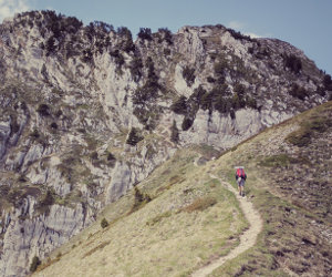
Does this trail look steep to you?
It looks steep to me! And I expect I would be walking up it slow and steady.
So, what do you think the grade is? 10 degrees? 20 degree?
When you look at the numbers, it's a bit disappointing. It's not really too impressive to think 'Hey, I just hiked a 9 degree hill for 2 miles!' but that's actually a steep trail. Really.
The Bright Angel Trail in the Grand Canyon, at its steepest, is less than 16 degree grade.
The North Kaibab Trail, over its length, averages less than 12 degree grade.
A few steepness examples:
- 5 - wheelchair ramp
- 30 - a steep ski slope
- 40 - home staircase
- 75 - ladder
- 80 - cliff face
Having hiked quite a few miles across the flats of Florida, hills of Minnesota and Wisconsin, and the steeps of the Appalachian and Rocky Mountains, I've found the grade of the trail makes a huge impact on my happiness while hiking. It's not just me - there are serious governing documents written about trail building that give great guidelines. Many of the guidelines are to prevent erosion and improve maintainability, but the experience of the visitor is also considered. A trail that is flat and straight is no better experience to a hiker than one that is steep and straight, possibly even a worse experience.

Everyone has their own 'Preferred Grade' graph like this one. When I can cruise along over easy low hills and shallow dips, I feel like I can walk all day. There is interest in finding out what is over the next rise.
I can still cover miles over challenging terrain that is a bit steeper, but my pace drops a little and my legs get tired after a few hours. Bends in the trail, tumbling creeks, varying plant life, and some higher views keep me motivated to hike on.
At some point, the trail turns strenuous. Now, my muscles are working and I need to slow my pace, take more breaks, and breathe more. My knees bother me on the downhill sections, but hiking poles help me along. The extra effort is worth it to see waterfalls, rocky outcrops, and far away landscapes from high on the side of a mountain.
When the trail is so steep I can envision a ladder working better than boots, and every downhill step jars my legs, then it is frustrating for me. It just stopped being any fun at all.
On the other hand, a flat, straight trail becomes boring quickly. You may cover ground quickly, but seeing where you're headed for hour after hour is monotonous.
From my experience, the Ice Age Trail is Easy with a few Challenging stretches. The Arizona Trail is Challenging with a couple Strenuous spots. The Appalachian Trail is Strenuous and sometimes Frustrating. The Florida Trail is Easy with some parts being Boring, especially roadwalks and levees.
Notice there are no numbers on the graph - the divisions are different for each person. Knowing what you prefer will help your hikes be more enjoyable. If a topographic map of a trail shows ups and downs with hundreds of feet of elevation change, realize that will require more effort and a slower pace. If the terrain is all forest, even the trail high points, your effort to climb up there may not reward you with any view.
The same graph can be used with a title of 'People I Meet on Trail'. You might prefer to have the trail completely to yourself and see no one for a week. Most people like to run into a few other people, but some like to have another group around at every campsite to feel safe. I like to cross paths with one or two people each day, and having others in a campsite once in awhile is fine. But, seeing people ahead and behind on the trail all day, hearing dogs and people and music at stops, and sharing a site every night with new people puts me up in the 'frustrating' area.
Knowing how much human interaction I prefer helps me determine what trail to hike, the time of year to hike it, and if I would be better off with a companion or alone.
Leave Comment
Posted: 12/27/2016
Posted: 12/27/2016
01/26/2017
Alive in Mexico
Testing is important. I didn't test my blogging process for my phone before leaving on my trip so I am unable to share daily updates. :-)
I'm having a great time exploring and will share a report of my hikes when I get home in a few days.
Food is great. Weather is great. People are great. It's all great!
I'm having a great time exploring and will share a report of my hikes when I get home in a few days.
Food is great. Weather is great. People are great. It's all great!
Leave Comment
Posted: 01/26/2017
Posted: 01/26/2017
03/13/2017
2017 Hike 100 on NCT
 The North Country Trail Association is at it again. These people are sneaky about tricking us into hiking more miles!
 Anyone that hikes a total of at least 100 miles on the NCT in 2017 can get a free patch, plus they are offering prizes and free resources to folks that sign up for the challenge.
If you really get into this, there's even a Grand Prize for someone that also fulfills their Built It Challenge - that's just doing two simple activities to spread the word and get others involved in the NCT project.
They've got forms, mileage log sheets, a flyer to print and share, and other stuff to help you out. Learn all about this fun challenge and the rules at their page.
I did the challenge last year, along with about 1,500 other people, and plan to repeat this year. Anyone want to get it done all at once and thru-hike the SHT in September?
Hike On!
Leave Comment
Posted: 03/13/2017
Posted: 03/13/2017
04/26/2017
SPOT Special
 I've been carrying a SPOT Messenger on my adventures since 2007. A SPOT is a satellite pinging device that can be used to request aid in an emergency, or just track your route. My wife is more comfortable knowing this extra bit of safety is along on each trek.
I use the tracking ability of the SPOT to ping a satellite about every 10 minutes. At any time during my hike, visitors here can see where I am on the trail. At the end of the trek, I have a map of my adventure and I can add geotagged pictures to my online adventure. Here's an example trek.
There is an annual fee, but here's a way you can save 20% off your service plan ...
- Purchase a SPOT device - locally at REI, Cabella's, Gander Mountain, Bass Pro Shops, EMS, Sportsman's Warehouse, or online at their web sites, or wherever you can get a good deal. It's not too difficult to find a very good deal on the device - I got mine free just before Christmas!
- Activate your SPOT device with whatever rescue and tracking options you want.
- Visit Referral Page and enter your Name and SPOT ESN to receive 20% off your next annual service plan.
By referring you, I also receive a discount on my next annual service plan, so we both win!
If you have questions about the SPOT GPS Messenger, I would be happy to answer them.
Hike On Safely
Leave Comment
Posted: 04/26/2017
Posted: 04/26/2017
05/12/2017
Spring Hikes
 My morning hikes have been more adventurous and interesting for the past few weeks, for two reasons.
1. My neighbor retired and has been hiking with me. Instead of just doing my normal route up and down the trail, we have branched out and are covering lots of different neighborhoods, trails, and paths. Also, our mileage has been around 6 miles rather than my old 5 miles! My SPOT track is drawing lines all over town as each day gets added to it. :-)
 2. I saw an ad on facebook for a 10x telephoto lens that you just clip onto your phone. It was something like $55 (wow!) so I looked around and found the exact same no-brand item someplace else for $8 (including shipping). The colors, markings, description 100% identical. So, I splurged and waited for it to arrive from China.
 You can see here some of the photos I have taken with it. I will post about it in a couple days with more details. Anyway, it has made it more interesting trying to get some shots.
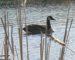 We are fortunate to have quite a few green areas around, plus some marshes, hills, and bike paths. Lots of varied walks to take in preparation for the big trek of the summer.
 There are also lots of places for birds and animals to roam. With the mild winter, it seems we have a plethora of rabbits, squirrels, and deer. The song birds are now migrating through, or deciding to stay awhile, and I even saw a bright orange and black Oriole yesterday.
 Until the ticks get thick, and the mosquitoes start to swarm, it will be easy to enjoy the trails. It is a good time to get out there and explore!
Hike On
Leave Comment
Posted: 05/12/2017
Posted: 05/12/2017
06/08/2017
Magnetic Rock Trail
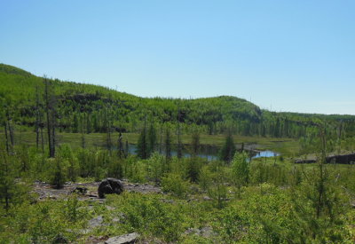
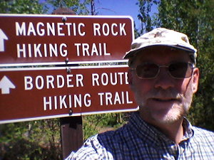 After finishing up presenting my wilderness first aid training yesterday, I had time to complete the short but popular Magnetic Rock Trail way up north on the Gunflint Trail in Minnesota. Perfect weather and a new location made for a most excellent walk through the great north woods.
The Magnetic Rock Trail (MRT) is also the western terminus of the Border Route Trail that follows close to the Canadian-USA border for about 65 miles where it ties into the Superior Hiking Trail. Also, the Kekekabic Trail heads west from this same location for 40 or so miles over to Ely, MN. All of these trails are bits of the very long North Country national scenic trail that goes from North Dakota to Vermont.
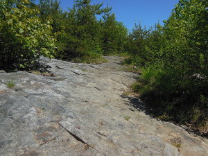 Much of the enjoyment of hiking a trail comes from the weather on the particular day you hike. I was fortunate to have crystal clear, bright blue sky. This didn't stop the temperature from rising over 80F, but very few bugs and little humidity made for an exception hour or so in the woods.
 This far north, the wilderness is made up of struggling vegetation clinging to a thin layer of dirt over solid rock. Much of the trail tread has been made by scraping away the dirt so it is firm, obvious, and easy to walk. The trail crosses one creek that had lots of water today, but I brought my own full bottle and needed no more. I am glad I brought water because there is little shade along the trail - fire has cleaned the area out. There are now low, thick brush and young trees growing. In a couple more years there will be plenty of shade.
In the open areas, I could see fields of blueberry bushes that should make the hike even more interesting later in August.
I was surprised to run into 5 other hikers in the middle of the week. One fellow had driven down from Canada just to check off this hike. The other 4 I didn't talk with except to say 'Howdy' as they passed on the trail. They did not have water and looked a bit hot.
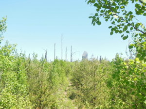
It is only about 1.5 miles from the trailhead to the monolith, but that last 1/4 mile or so always seems to take a long time. I was very curious just how big the rock would be since I've heard of it but never seen it. I was looking ahead at every opportunity and finally caught my first glimpse through the trees. Off in the distance, it reminded me of Devil's Tower in miniature.
It took me another 5 minutes to reach, but it is certainly possible to suddenly notice it right in front of you if you are watching your footing or otherwise distracted. As the forest grows, this will be more the case.
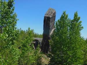
Getting closer, it was hard to see how this one formation could be standing all alone. Glacial eradicts that are deposited can be huge, but all that I've seen are more boulder-shaped from scraping along ice and rivers. This massive standing tower just does not fit the expectation.
Reaching the rock, it was much taller than I expected. There's no hype with this one! I had brought a compass and magnet along just for this moment, but I then remembered it was sitting on the passenger seat in my car. :-(
The rock is layered vertically, rather than horizontally, making it obvious that it has been stood on end. Around the base, there are huge chunks that have flaked off over time, due to freezing and splitting. Eventually, this sight will be only a jumbled pile of rock.
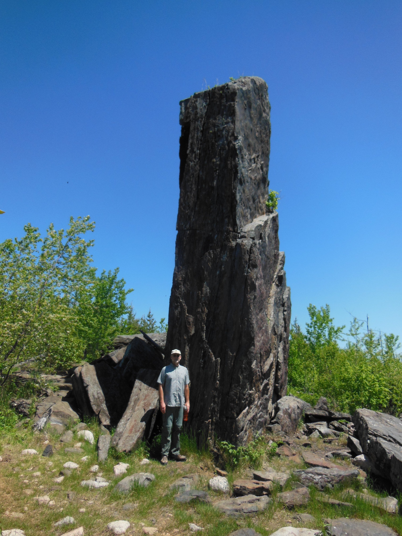 (Click pic for large pic)
At a bit over 6 foot, you can see that Magnetic Rock is at least 4 times my height, making it over 24 feet tall. I was pleased to see no graffitti, and the shade on the north side was a welcome rest before the hike out.
Please remember to scrape off your shoes before and after your hike on the installed device at the trailhead so you do not transport invasive organisms.
The biggest challenge of this easy, interesting, hike is getting here. Grand Marais, MN is 2+ hours northeast of Duluth, MN along highway 61 following the North Shore of Lake Superior. The Magnetic Rock Trail is another hour north of Grand Marais on the Gunflint Trail. But, it is all beautiful driving and just takes time.
Since you came this far for the hike, you might as well drive another 9 miles north to say you made it all the way to the end of the Gunflint Trail - and you're only a couple miles from Canada at that point.
Leave Comment
Posted: 06/08/2017
Posted: 06/08/2017
Older Posts Newer Posts
Find more Hiking Resources at www.HikingDude.com
Follow Me
Recent Comments