Continental Divide Trail

My Continental Divide Trail Hike | ||||
| I hope to hike the Continental Divide Trail in the near future. Since it's right down the middle of the country, maybe someone would like to join me? | ||||
Continental Divide Trail Statistics | ||||
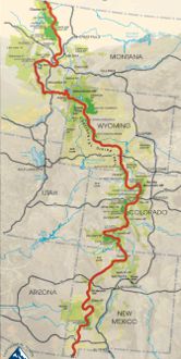
| States | Montana, Idaho, Wyoming, Colorado, New Mexico | |||
| Distance | 3100 miles - trail reroutes happen so this is an estimate of the trail length. When I complete the trail, I'll let you know how many steps it took me since I'll wear a pedometer the distance. | |||
| Total Elevation | Estimates vary depending on the elevation sampling sizes taken, but the generally accepted number is around 450,000 feet gained over the length of the trail. This is the accumulated elevation from climbing up to passes and ridges and down to valleys and streams. | |||
| Terminus | South: Antelope Wells, NM on Mexican border North: Glacier National Park, MT | |||
| Highest Point | 14279ft at Grays Peak in Colorado | |||
| Lowest Point | 3900ft at Columbus, New Mexico | |||
| Map |  Click for Large Map | |||
| Terrain | Desert with high daily temperatures and low night temperature in New Mexico. Very high altitudes over much of the trail, the highest national scenic trail. Scarce or non-existent trail markings much of the way. | |||
| History | Designated into the National Trails System in 1978. It is about 70% complete in 2011. | |||
| Challenges | No hi-traffic, groomed trail like the AT - on the CDT you have to find your own path much of the way. Travel and camping on snow and ice with high wind and low oxygen. High altitude sickness. Bears, cougars, moose. Lightning and wind. Intense sunburn and snowblindness. Turbulent water crossings. Other than that, it should be fun. :-) | |||
| Time Window | Most start around April 1st going northbound - leaving too early means high snow in Colorado. Southbounders leave in mid-June - earlier and the high snow and deep river crossings may stop you. | |||
| Time to Hike | Typically takes about 180 days, averaging 17 miles per day. Expect lower daily averages than AT and PCT due to elevation and rough terrain. | |||
| Permits | Back country permits required in Rocky Mountain, Yellowstone, and Glacier national parks. | |||
| Thru-hiker Tally | About 30 attempt a thru-hike each year. I'm still searching for a count. | |||
Trail Links | ||||
| Google Earth | View Trail with google earth | |||
| Full Maps | ||||
| Agencies | Continental Divide Trail Alliance
Land Managers and Partners of the Continental Divide Trail
| |||
Hike On: My Hikes
Find more Hiking Resources at www.HikingDude.com


Follow Me
Recent Comments