

Ice Age Trail
My Ice Age Trail Hike
I hiked the Ice Age Trail from August 3 to September 28, 2013.
I took 2,248,576 steps to travel about 1095 miles.
Journal Map Photos Gear Food Expenses Supporters Stats
My Gear
My pack weighed under 23 pounds with food and water. Since the trail passed by many small towns, parks, and farms, there was never a need to carry many days of food and water was never an issue. This helped keep pack weight down.
| Item | Oz | $$ | Notes |
| G4 backpack | 16 | $40 | 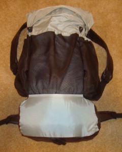 made myself from pattern. made myself from pattern.Comfortable, light, and plenty of room for all my gear. I used my new green version most of the trip. |
| Sleeping | |||
| shelter | 30 | 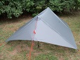 silnylon tarp with internal bug nest from Bear Paw Wilderness Designs, including stakes, lines, and groundsheet. silnylon tarp with internal bug nest from Bear Paw Wilderness Designs, including stakes, lines, and groundsheet.This is a very nice shelter, but I switched back to my home-made shelter after a few weeks. I was a bit too long for the bug nest, being almost 6-2. Bear Paw has larger versions, but I didn't have time to get one ordered. | |
| shelter | 28 | $75 | 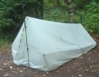 silnylon shelter I made, including stakes, lines, and groundsheet. I treated it with silicone spray, added a bug screen edge and floor, and it worked just fine. silnylon shelter I made, including stakes, lines, and groundsheet. I treated it with silicone spray, added a bug screen edge and floor, and it worked just fine. |
| sleeping quilt | 32 | $80 | 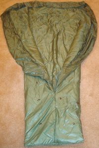 I used this quilt I made myself from pattern. Same as my silver quilt for the AZT, but only 1 layer of insulation. It's 8 oz. lighter, but not as warm. I used this quilt I made myself from pattern. Same as my silver quilt for the AZT, but only 1 layer of insulation. It's 8 oz. lighter, but not as warm. |
| Exped Synmat 7 UL Pad | 16.2 | $155 | 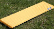 comfortable, warm, light mattress for restful nights. comfortable, warm, light mattress for restful nights. |
| Exped Schnozzel Pumpbag | 2.0 | $25 | 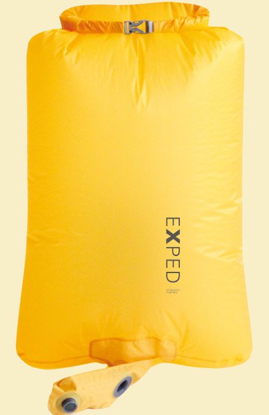 Fills pad quickly with dry cold air instead of hot moist breath. Serves as inflatable pillow and storage in pack for night clothes. Fills pad quickly with dry cold air instead of hot moist breath. Serves as inflatable pillow and storage in pack for night clothes. |
| Cooking | |||
| Snow Peak LiteMax stove | 2.0 | $45 | This stove did great, but we didn't actually cook very often. Many more restaurant - bar - home meals than I expected along the way. |
| Giga Power fuel | 7.0 | $35 | 4oz. fuel and 3oz. canister. |
| cook kit | 5.8 | $25 | includes spoon, pot, foil lid, stand, windscreen, and lighter. |
| food cozy | .8 |  insulates food package while the hot water is heating it up. Saves fuel and works super. insulates food package while the hot water is heating it up. Saves fuel and works super. | |
| food | 0-7lb. | Never carried more than 5 days of food. | |
| Water | |||
| water filter | 4.2 | $51.70 | Bought a new Sawyer Squeeze, so now I have an extra. Wound up filtering water ZERO times on this trip! Lots of faucets, drinking fountains, wells, bathrooms, restaurants along the way. |
| water bottles | 1.2 | two .6L throw-out bottles - cheap, easy, light. | |
| water bag | .9 | $8 | 1L Platypus roll-up, just for backup. |
| water | 1-4lb. | water is plentiful, so no need to carry much. 2.2lb/L | |
| Clothes | |||
| BSA wicking t-shirt | 11.2 | $20 | light, synthetic - 2 shirts |
| arm warmers | 3.8 | $9 | 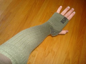 made from kneelength socks for chilly evenings and mornings, instead of long-sleeve shirt made from kneelength socks for chilly evenings and mornings, instead of long-sleeve shirt |
| bug suit | 6.0 | $28 | 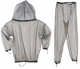 Super protection from blood suckers. Very light, did not need bug spray, easy on and off, no slime on my skin. Super protection from blood suckers. Very light, did not need bug spray, easy on and off, no slime on my skin.This has been the best investment for this trip - lots of mosquitos but very few bites. |
| BSA zip-off pants | 17.2 | light and sturdy | |
| BSA socks | 5.7 | 3pr. hiking socks. Wore them out and had to buy more. | |
| shoes | 32.5 | $45 | New Balance 606 - from ebay. |
| underwear | 4.2 | 2pr. Bought 4 more along the way. | |
| BSA hat | 3.5 | baseball style | |
| bandanna | 1.0 | ||
| Electronics | |||
| cellphone | 4.3 |  for daily blogs and pics. for daily blogs and pics. | |
| camera | 7.7 | $125 | new Nikon with 18x zoom. I'm hoping for more wildlife pics. bought on ebay. |
| tracker | 4.2 | pings to satellite with my location. | |
| Other | |||
| pedometer | .6 | $25 | 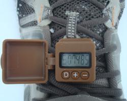 track my steps, just for fun. Bummer, I lost this in a swamp partway through the trek and had to estimate steps after that. track my steps, just for fun. Bummer, I lost this in a swamp partway through the trek and had to estimate steps after that. |
| umbrella | 8.1 | $35 | used it on long, sunny roadwalks to keep cool. |
| rain poncho | 3.4 | $4 | cheap disposable to cover me and pack from rain - taking 2. |
| maps | 2 | $35 | IATA Atlas map set. |
| 1st aid kit | 2.3 | basic personal items - bandaids, pain relief, tape, ... | |
| pad repair kit | .4 | ||
| compass | 1.1 | ||
| knife | 1.1 | tiny, single blade. | |
| toothbrush | 1.3 | includes paste | |
| ear plugs | 0 | ||
| 50ft. core | 1.5 | hanging food to protect from animals | |
| toilet kit | 2.8 | TP, Purell | |
| headlamp | .5 | $11 | 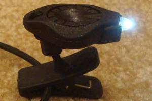 Awesome photon light, with spare batteries. One set of batteries lasts about 10 days. Awesome photon light, with spare batteries. One set of batteries lasts about 10 days. |
| Stick Pic | .4 | self-pictures and videos | |
| misc. | 12 | 2 garbage bags, whistle, clippers, thermometer, extra batteries, and other small items | |
| Total | 16lbs 4lbs worn, not in pack 12lb pack weight 2 to 11lb food & water 14 to 23lb - total weight | ||
My Food
My planned menu was supplemented with quite a few restaurant and home meals, so I got lots of variety:
- Breakfast: 2 poptarts or granola bars. I'm rarely hungry before starting.
- Lunch: peanut butter and honey mixed, on ritz crackers. I didn't get tired of it, but came close.
- Snacks: Snickers, trail mix, sunflower kernels, peanut M&Ms, raisins. I could probably live on just Snickers for a month, but peanut M&Ms are awesome, too.
- Dinner: Knorr noodles or rice, salmon or tuna or chicken pouch, olive oil. Lots of flavors and combinations are possible. I actually ate very few of these and did more non-cooking food.
- Drink: mostly water, but diluted Gatorade occasionally. I also had chocolate protein powder mix and I really liked that.
- Daily vitamin
My Expenses
- travel to trailhead from home - $150 - drove home to take a week off during heat wave, so that cost a bit.
- shuttling car during hike - $400 - much more than expected since we shuttled two cars for a few days and did shorter shuttles than I planned.
- travel from trailend to home - $15
- gear - $240 (camera, filter, shoes) - most of my gear from last year is fine.
- maps - $35
- food - $600 - restaurant food was more expensive, but made the hike more fun and interesting since I met more people.
- lodging - $14 - stayed with friends, family, Scouting families, and open camping. Paid for 1 night in Kettle Moraine forest.
- Total - $1500 - about $1.33/mile
Ice Age Trail Statistics
| States | Wisconsin | |||
| Distance | Almost 1100 miles - much of the trail is not yet complete so there is quite a bit of roadwalking and alternate routes until land is acquired and set aside for the entire route. I took about 2,250,000 steps from end to end. | |||
| Total Elevation | The total cumulative elevation climbed is undocumented at this time. The closest estimate based on DNR data from 1998 is 25,000 feet. It is most likely under 40,000 feet due to the flat terrain. | |||
| Terminus | East: Potawotami State Park, Sturgeon Bay West: Interstate Park | |||
| Highest Point | Lookout Mountain, 1920ft | |||
| Lowest Point | Lake Michigan, 580ft | |||
| Map | 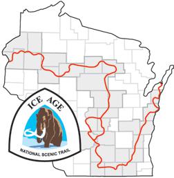 Click for Large Map | |||
| Terrain | All of Wisconsin is fairly rolling landscape with no high elevations or long, steep climbs. Since much of the trail is incomplete at this time, flat roadwalking accounts for many miles of the trail. The trail is marked with yellow blazes. Since it gets relatively light traffic in some sections, volunteer efforts are key in maintaining the trail corridor. | |||
| History | Founded in 1958 by Ray Zillmer. Established as a National Scenic Trail in 1980. First thru-hiked by James Staudacher in 1979. | |||
| Challenges |
Much of the trail has no camping allowed, being on private property. Connecting with local residents for permission to camp overnight is a key skill to learn. Traffic while walking on roads over connecting routes can be dangerous. The western sections cross public forests where bears, wolves, and other animals may be encountered. Hunting season needs to be considered in the fall. There were a couple sections closed to hunting starting Sept. 1 | |||
| Time Window | April through October. Spring has wet weather, summer has high humidity and mosquitos, late August through September are the best bet with late October bringing cold and hunting season. | |||
| Time to Hike | Typically takes 7 to 10 weeks. Speed record is 22 days set by Jason Dorgan in 2007. | |||
| Permits | There are no fees or permits required to hike the Ice Age Trail. | |||
| Thru-hiker Tally | The Ice Age Trail Alliance gives the name 1000 Miler to anyone who completes the entire trail, all at once or in sections. I am #81 on that list and unofficially the 22nd thru-hiker. | |||
Trail Links | ||||
| Google Earth | View Trail with google earth | |||
| Full Maps | IATA Interactive Map | |||
| Agencies | Ice Age Trail Alliance
| |||
Land Managers and Partners of the Ice Age Trail
| ||||
Hike On: My Hikes
All Comments:
Apr 12, 2012 - Sarah
I am looking forward to hearing about your hike.
One of my sons and I have been section hiking this trail, as well as the AT,and have completed about 550 miles so far, from Sturgeon Bay to north of Verona, and from near Antigo to near Westfield,
and a few random spots in addition. What a treat it is to
see parts of beautiful Wisconsin at walking speed.
Jul 09, 2012 - Jean
I am going to start section hiking as well. I am starting with those areas that have primitive camping allowed and then will look at hiking some of the other sections....I look forward to your tales...
Sep 17, 2012 - Jared
Looking for people to section hike with me
jaredwildenradt@Hotmail.com
Been doing sections for the past few months.
Just completed 4 sections this weekend!
Ive live next to the Alliance Head Quarters in Cross Plains so feel free to hit me up if your hiking past Im good for a free dinner and some chat or a place to camp.
Sep 22, 2012 - Hiking Dude
Jared - hey, thanks! Keep up the good hiking and I'll be in touch as my hike gets closer.
Feb 23, 2013 - Nate
I bookmarked your blog as I am very interested in your journey. I cant wait to hear about it! As a recent resident of wisconsin The Ice Age Trail and intrigued me and I one day hope to make the thru hike myself!
Mar 24, 2013 - N
A friend & I plan to through-hike the IAT in summer 2014 for about 10 weeks. Looking forward to your feedback! Happy hiking!
Apr 22, 2013 - kelley
Nate I bookmarked your site and look forward to reading it. My two sons and I will be hiking the trails from Cross Plains to Door County this June. I am so excited and cannot wait. I know it is going to be hard at times but the experience is going to be amazing not to mention the accomplishment. I wish you well on your journey.
Dec 04, 2017 - Eric
I have a friend who is planning a through hike next April '18. Mid-60's overweight and truly a novice at best. He is planning on two months duration tops. Is he being reasonable or dreaming? I've got extensive Outward Bound experience and think that averaging 20 miles a day for 60 days is unrealistic. Thanks much for your great site!
Dec 06, 2017 - Hiking Dude
@Eric - 20mpd is an easy average on the IAT for experienced, in
shape backpackers. When you say "overweight" and "novice", I
tend to agree that his chances of completing 1100 miles in 60
days, or any number of days, is pretty low. He really should
get some multi-day treks completed before tackling such a big
one. The average low temperature in April is around freezing -
waiting until May boosts that 10 degrees.
But, if he wants to do it, then good for him! He might surprise you with his perseverance. It's not remote wilderness so he can bail off pretty much any time, if needed.
But, if he wants to do it, then good for him! He might surprise you with his perseverance. It's not remote wilderness so he can bail off pretty much any time, if needed.
Ask a Question
Find more Hiking Resources at www.HikingDude.com
Follow Me
Recent Comments