Pacific Crest Trail

My Pacific Crest Trail Hike
I hope to hike the Pacific Crest Trail in coming years. It strikes me as being the most scenic of the trails. I'd love to share the adventure with another person, rather than hiking it alone. Interested? Give me a holler.
Pacific Crest Trail Statistics
| States | California, Oregon, Washington |
| Distance | 2650 miles - trail reroutes happen so this is an estimate of the trail length. When I complete the trail, I'll let you know how many steps it took me since I'll wear a pedometer the distance. |
| Total Elevation | Estimates vary widely depending on the elevation sampling sizes taken, but the generally accepted number is around 450,000 feet gained over the length of the trail. This is the accumulated elevation from climbing up to passes and ridges and down to valleys and streams. |
| Terminus | South: Campo, CA on Mexican border North: Manning Park, British Columbia |
| Highest Point | 13153ft at Forester Pass in the Sierra Nevada |
| Lowest Point | 180ft at Bridge of the Gods on Oregon-Washington border |
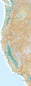
| Map |  Click for Large Map |
| Terrain | Desert with high daily temperatures and low night temperature in southern California. Very high altitudes in the Sierra Nevada. Generally considered the most scenic of the national scenic trails. Well-marked trail the entire length. Most extreme elevation range of all the National Scenic Trails. |
| History | Designated into the National Trails System in 1968 and declared 100% complete in 1993. |
| Challenges | Deep snow in Sierra Nevada. Turbulent water crossings. High altitude sickness. Lightning storms. Incessant rain through Washington for the end of the northbound trek. |
| Time Window | End of April, beginning of May. Too early and deep snow in the Sierras, too late and snow in Washington. Most start around April 25, northbound. |
| Time to Hike | record set in 2011 is 64 days by Scott Williamson. Typically takes 140-180 days. |
| Permits | Thru-Permit required for hikes longer than 500 miles. See PCTA. Shorter hikes require permits in wilderness areas, national parks, and other restricted areas. |
| Thru-hiker Tally | PCTA registry of names that have been sumitted, certainly not a complete listing. From 2011 back to 2006, totals are: 117, 187, 76, 81, 84, 132 |
Trail Links
| Google Earth | View Trail with google earth |
| Full Maps | |
| Agencies | Pacific Crest Trail Association |
Land Managers and Partners of the Pacific Crest Trail
| Forest Service |
| National Park Service |
| Bureau of Land Management |
| California State Parks |
Hike On: My Hikes
All Comments:
Jan 15, 2018 - Heidi
Thanks for sharing your experiences. Thoughts on hiking Pacific
Crest Trail SOBO? Any chance you’re thinking of doing it this late
spring / summer (2018)?
Jan 15, 2018 - Hiking Dude
@Heidi - This summer looks like a few shorter treks for me. Also,
after all the fires this past year, I think the PCT will be
recovered more in a couple years. You might check out the PCT
Trail Closures. Quite a few miles are still closed.
Ask a Question
Find more Hiking Resources at www.HikingDude.com


Follow Me
Recent Comments