
Kekekabic Trail

My Kekekabic Trail Hike
I hiked the Kekekabic Trail from its western terminus near Ely, MN to its easter terminus on the Gunflint Trail, and back to the west with my wife on October 3 to October 8, 2020.
This was Kelly's first thru-hike and she set a Female Supported Fastest Known Time for the trail - see FKT page!
My Gear
My pack weighed 27 pounds with including 7 days of food.
No new gear was purchased for this hike.
| Item | Oz | $$ | Notes |
| G4 backpack | 16 | $0 | 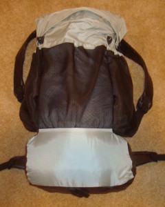 made myself from pattern. made myself from pattern.Comfortable, light, and plenty of room for all my gear. I used my old green one for one last? hike. |
| Sleeping | |||
| shelter | 30 | $0 | 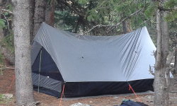 We used my Bear Paw Wilderness Designs La Garita shelter with 2-person bug net includes stakes. It worked wonderfully. We used my Bear Paw Wilderness Designs La Garita shelter with 2-person bug net includes stakes. It worked wonderfully. |
| sleeping quilt | 40 | $0 | 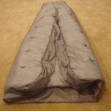 I made this quilt from a pattern for my AZT hike. I made this quilt from a pattern for my AZT hike. |
| blue CCF pad | 10 | $0 | cheap, indestructible, and comfortable enough. |
| Cooking | |||
| alcohol stove | 1.1 | $0 | Just boiling water. |
| fuel | 28 | $7 | disposable bottles of alcohol |
| cook kit | 5.8 | $25 | includes spoon, pot, foil lid, stand, windscreen, and lighter. |
| food cozy | .8 |  insulates food package while the hot water is heating it up. Saves fuel and works super. insulates food package while the hot water is heating it up. Saves fuel and works super. | |
| food | 8 lbs. | $0 | 7 days of food. |
| Water | |||
| water filter | 4.2 | $0 | Sawyer Squeeze filter continues to work wonderfully. |
| water bottles | 1.2 | $0 | two .6L throw-out bottles - cheap, easy, light. |
| water | 2lb. | water is plentiful most of the time, 2.2lb/L | |
| Clothes | |||
| baseball hat | 3.5 | $1 | with home-made sun cape to protect ears and neck. |
| wicking t-shirt | 11.2 | $0 | light, synthetic. Same old one refuses to wear out! |
| long sleeve nylon shirt | 12 | $0 | for sun protection. |
| BSA zip-off pants | 17.2 | light and sturdy | |
| Darntough socks | 2.9 | Second pair - they replace them when they wear out! | |
| underwear | 4.2 | 3 pr. | |
| shoes | 26 | $0 | Astral Footwear |
| bandanna | 2.0 | $1 | 2 of them, too many uses to list here. |
| down jacket | 16 | $70 | REI sale, evening warmth and used for pillow wrapped in bandanna. |
| Electronics | |||
| cellphone | 5.2 | LG Stylo 3. This is my watch, alarm, phone, camera, gps. | |
| tracker | 4.2 | pings to satellite with my location. Batteries last three weeks when on for 12 hours/day. | |
| headlamp | .5 | $0 | 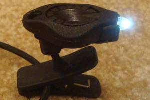 Awesome photon light. One set of batteries lasts about 10 days. Awesome photon light. One set of batteries lasts about 10 days. |
| batteries | 2.0 | $10 | 4 AAA lithium backups for tracker, and 4 CR2016 coin batteries for headlamp - purchased online for pennies. |
| Venza Maps App | 0.0 | $0 | These electronic maps are great tools and they weigh nothing. |
| Other | |||
| trek poles | 14 | $0 | Still using Walmart pair that refuse to die |
| rain poncho | 3.4 | $4 | cheap disposable to cover me and pack from rain - taking 2. |
| rain skirt | 2.0 | $1 | Just a garbage bag cut open and cinched around waist. |
| guide | 4 | $17 | Kekekabic Trail Guide |
| food bag | 9 | $90 | we each have an Ursack Major S29.3 AllWhite bag |
| 1st aid kit | 3 | basic personal items - bandaids, pain relief, tape, liquid skin, CPR mask, gauze pads, allergy meds, ... | |
| compass | 1.1 | ||
| knife | 1.1 | tiny, single blade. | |
| toothbrush | 1.3 | includes paste | |
| ear plugs | 0 | I'm taking a bunch, just in case. | |
| toilet kit | 2.8 | TP, Purell | |
| misc. | 12 | 2 garbage bags, whistle, clippers, thermometer, and other small items | |
| duct tape | 1.5 | Duct tape has many uses, but I'm taking bright orange for high visibility. | |
| stickers | 3 | As usual, taking some Hiking Dude stickers to hand out to folks I meet. | |
| Total | ~29 lbs - total weight | ||
My Food
- Breakfast: 2 protein bars & cocoa
- Lunch: salami and crackers
- Snacks: Austin crackers, peanut M&Ms, smokehouse almonds, jerky
- Dinner: Food for Sole meals, chicken pouch
- Drink: just water. lots and lots of water.
- Daily vitamin
My Expenses
- travel to trailhead and back - $40
- food - $47 restaurants (in transit), $100 trail food
- Total - ~$200
Kekekabic Trail Statistics
| States | Minnesota, all within the Boundary Waters Canoe Area Wilderness |
| Distance | 81.2 miles - 40.6 each direction |
| Total Elevation | not very much, lots of hills, but no mountains. |
| Terminus | East: Gunflint Trail West: Snowbank Lake |
| Highest Point | 1920ft - site of old lookout tower |
| Lowest Point | 1430ft - bog near west terminus |
| Map | 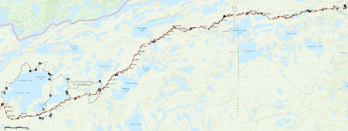 Click for Interactive Map |
| Terrain | The trail has a challenging tread of rocks, bogs, and overgrowth but there are no big climbs or summits. The trail is not blazed like the AT or PCT and advanced navigation skills are required. |
| History | The trail was built in the 1930s by the CCC and USFS to access fire lookout towers. It became unused but was reborn as a recreational trail in the 1960s. The USFS stopped maintaining the trail in the early 1980s so use fell off. The Kekekabic Trail Club was formed in 1990 to recover and maintain the trail. The KTC became a chapter of the North Country National Scenic Trail Association in 2014, and the NCT was rerouted to use the Kek in 2019. |
| Challenges | Overgrowth of brush and ferns obscure the tread over the spring and summer. Very little trail markings. Limited campsites. |
| Time Window | May through October. Snow and snowmelt make the trail swampy early. Weather and tree colors make September a prime time to hike. |
| Time to Hike | Typically 3 to 5 days. |
| Permits | BWCAW permit required. |
| Thru-hiker Tally | not tracked |
Trail Links
| Google Earth | View Trail with google earth |
| Full Maps | Interactive Map |
| Agencies | North Country Trail Association |
Land Managers and Partners of the Kekekabic Trail
| Forest Service |
| Partnership for the Nat'l Trails System |
Hike On: My Hikes
All Comments:
Mar 10, 2021 - Greg
Thanks for your overview of the trail. It is definitely on our to do list. Also watched your video
on you tube of the hike.
Ask a Question
Find more Hiking Resources at www.HikingDude.com


Follow Me
Recent Comments