

Pacific Northwest Trail
My Pacific Northwest Trail Hike
I hiked the Pacific Northwest Trail from the continental divide in Glacier National Park in Montana to Cape Alave on the Washington coast with my son from July 13, 2017 to September 16, 2017.
I wore a tiny pedometer the entire trip and figure I took about 2,587,370 steps to hike about 1111 miles.
My Gear
My pack weighs right around 17 pounds without food and water. The most days of food I carried was 9 (ouch!). I mostly resupplied from stores in towns, but sent a food package to Ross Lake Resort.
The prices are only for costs of this trip. Almost all gear was still working well from previous treks, but some of it wore out this time, so see the IAT Hike page for costs.
| Item | Oz | $$ | Notes |
| G4 backpack | 16 | $0 | 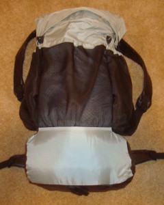 made myself from pattern. made myself from pattern.Comfortable, light, and plenty of room for all my gear. I used my green one and Josh used this grey one. After 5 seasons, they are finished so I'll make a new one this winter. |
| Sleeping | |||
| shelter | 30 | $0 | 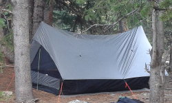 We used my Bear Paw Wilderness Designs La Garita shelter with 2-person bug net includes stakes. It worked wonderfully. We used my Bear Paw Wilderness Designs La Garita shelter with 2-person bug net includes stakes. It worked wonderfully. |
| sleeping quilt | 40 | $0 | 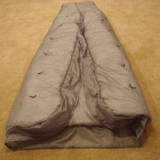 I made this quilt from a pattern for my AZT hike. We used both my lighter weight green version and this warmer one. I made this quilt from a pattern for my AZT hike. We used both my lighter weight green version and this warmer one. |
| Exped Synmat 7 UL Pad | 16 | $0 | 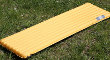 comfortable, warm, light mattress for restful nights. Josh gets a simple blue cell foam pad. Baffles broke, so I switched to a simple blue cell foam pad in Idaho. comfortable, warm, light mattress for restful nights. Josh gets a simple blue cell foam pad. Baffles broke, so I switched to a simple blue cell foam pad in Idaho. |
| Exped Schnozzel Pumpbag | 2.0 | $0 | 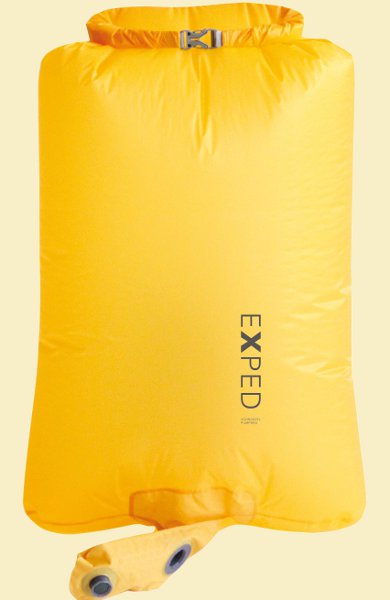 Fills pad quickly with dry cold air instead of hot moist breath, and keeps me from getting dizzy! Serves as food bag at night and storage for clothes in pack during day. Fills pad quickly with dry cold air instead of hot moist breath, and keeps me from getting dizzy! Serves as food bag at night and storage for clothes in pack during day. |
| Exped pillow | 2.7 | $0 | 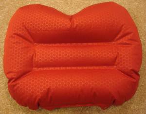 xmas present. xmas present.Pretty comfortable and worth the extra bit of weight. Baffle broke in it after 7 years, so it's garbage now. I'm sure I'll get another. |
| Cooking | |||
| No cooking on this trip. | |||
| food | 2-15 lbs. | $0 | From 1 to 9 days of food. |
| Water | |||
| water filter | 4.2 | $0 | Sawyer Squeeze filter continues to work wonderfully. |
| water bottles | 1.2 | $0 | two .6L throw-out bottles - cheap, easy, light. |
| water | 2-8lb. | water is plentiful most of the time, can carry up to 4L. 2.2lb/L | |
| Clothes | |||
| Lutherhaven baseball hat | 3.5 | $1 | with home-made sun cape to protect ears and neck. |
| wicking t-shirt | 11.2 | $0 | light, synthetic. Same old one refuses to wear out! |
| long sleeve nylon shirt | 12 | $0 | for sun protection. |
| BSA zip-off pants | 17.2 | light and sturdy | |
| Darntough socks | 2.9 | I got these on the A.T. and they seemed very nice, but I didn't get to wear them long enough. They are warm, soft, and sturdy. These socks were awesome! Still waiting for them to wear out. Both pair wore through. I've returned them and am waiting for replacements. Bought cheap replacement socks. | |
| underwear | 4.2 | 3 pr. | |
| shoes | 32.5 | $20 | Ozark Trail from WalMart. Got them for practice hiking and they fit nice, so I'm going with them. They last about 400 miles before the soles wear through. |
| bandanna | 2.0 | $1 | 2 of them, too many uses to list here. |
| down jacket | 16 | $70 | splurge item for this hike. Used it many times, and used for pillow on warm nights. |
| Electronics | |||
| cellphone | 5.2 | for daily blogs and pics. Upgraded to LG Stylo 3. This is my watch, alarm, phone, camera, gps. | |
| tracker | 4.2 | pings to satellite with my location. Batteries lasted three weeks when on for 12 hours/day. | |
| headlamp | .5 | $0 | 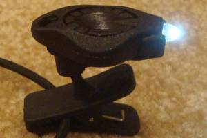 Awesome photon light. One set of batteries lasts about 10 days. Awesome photon light. One set of batteries lasts about 10 days. |
| batteries | 9.0 | $15 | 12 AAA lithiums for tracker, and 24 CR2016 coin batteries for headlamp - purchased online for pennies. |
| PNT Map App | 0.0 | $50 | For help with water sources and location. These electronic maps are great tools and they weigh nothing. We switched to using HikerBot app and it was much more useful, and free. |
| Other | |||
| trek poles | 14 | $0 | Using a new, lighter pair this hike that I got for Christmas. One pole broke for each of us. |
| pedometer | .6 | $0 | 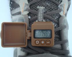 track my steps, just for fun. The great folks at GeoPalz gave me a replacement for the one I lost in the wilds of Wisconsin. track my steps, just for fun. The great folks at GeoPalz gave me a replacement for the one I lost in the wilds of Wisconsin. |
| rain poncho | 3.4 | $4 | cheap disposable to cover me and pack from rain - taking 2. |
| rain skirt | 2.0 | $1 | Just a garbage bag cut open and cinched around waist. |
| guide | 4 | $30 | PNT Guide. |
| maps | 4 | $50 | PNT Guide. |
| bear spray | 10 | 0 | we each have one, it's like a lead weight! |
| food bag | 9 | $190 | we each have an Ursack Major S29.3 AllWhite bag. Most expensive items this trip. |
| 50ft. core | 1.5 | hanging food to protect from animals - (never used it) | |
| 1st aid kit | 3 | basic personal items - bandaids, pain relief, tape, liquid skin, CPR mask, gauze pads, allergy meds, ... | |
| pad repair kit | .4 | ||
| compass | 1.1 | ||
| knife | 1.1 | tiny, single blade. | |
| toothbrush | 1.3 | includes paste | |
| ear plugs | 0 | I'm taking a bunch, just in case. | |
| toilet kit | 2.8 | TP, Purell | |
| misc. | 12 | 2 garbage bags, whistle, clippers, thermometer, and other small items | |
| duct tape | 1.5 | Duct tape has many uses, but I'm taking bright orange for high visibility. | |
| stickers | 3 | Taking some Hiking Dude stickers to hand out to folks I meet. | |
| Total | ~19 lbs - 4lbs worn, not in pack = ~15lb pack weight + ~4 to 15 lbs food & water = ~19 to ~30 lb pack ~23 to 34 lbs - total weight | ||
My Food
We're going cookless:
- Breakfast: 2 poptarts, 2 granola bars - 750 calories. I'm rarely hungry before starting my morning hike.
- Lunch: nutella or PBJ on tortillas, fig bars - 600 calories.
- Snacks: Austin crackers, peanut M&Ms, trail mix, sunflower kernels, jerky, Lil Debbie desserts - 1000 calories
- Dinner: protein powder after hiking and tuna or sausage on tortillas, Nutty Bar for dessert - 600 calories.
- Drink: just water. lots and lots of water.
- Daily vitamin
My Expenses
- travel to trailhead from home - $150 - train to Glacier
- travel from trailend to home - $150 - plane from Seattle
- gear - $20 shoes, $25 shoes, $20 shoes
- guide and maps - $85
- food - $234 restaurants, $646 trail food
- lodging - $28 Glacier NP, $90 Olympic NP, $25 Forks campground, $16 Lake Pierre campground
- Total - $1489
Pacific Northwest Trail Statistics
| States | Washington, Idaho, Montana |
| Distance | 1200 miles - but fire detours and alternate routes change that a bit. |
| Total Elevation | The total cumulative elevation climbed estimated to be 200,000 feet. |
| Terminus | East: Glacier National Park, MT West: Cape Alava, WA |
| Highest Point | Cathedral Pass, MT - 7600ft |
| Lowest Point | Pacific Ocean, Cape Alava, WA - 0ft |
| Map |  Click for Large Map |
| Terrain | It's all downhill from the Continental Divide to the Pacific. :-) The trail traverses high alpine mountains, coastal rain forests, and great pine forests over a route that receives light traffic in most sections. The trail is not blazed like the AT or PCT and advanced navigation skills are required. |
| History | Conceived in 1970 by Ron Strickland. Established as a National Scenic Trail in 2009. First thru-hiked by 5 people in 1977. |
| Challenges | The Pacific Northwest is notorious for grey, dreary, drizzly weather. Possibly long stretches of rain, especially towards end of summer. Snow hazards early and late in season. Eastern half of trail can be brutally hot and dry in summer. Navigation through unmarked wild lands, not just following white, blue, or yellow blazes day after day. Grizzlies and wolves on eastern third of trail. |
| Time Window | June through November. Leaving too early heading west and the Montana snow will hamper progress. July and August are typically the best months for weather and bugs in the Northwest forests and on the Olympic peninsula. |
| Time to Hike | Typically takes 6 to 10 to weeks. |
| Permits | Glacier NP, North Cascades NP, and Olympics NP all require permits. |
| Thru-hiker Tally | Under 500. |
Trail Links
| Google Earth | View Trail with google earth |
| Full Maps | PNT Maps |
| Agencies | Pacific Northwest Trail Association |
Land Managers and Partners of the Pacific Northwest Trail
| Forest Service |
| National Park Service |
| Partnership for the Nat'l Trails System |
Hike On: My Hikes
All Comments:
May 04, 2013 - Harly Drum
Good luck and have fun. I have my PNT journal from 2005 posted on my blog. www.nwhikingblog.com
Mar 19, 2016 - Reed
Land Managers and Partners of the Pacific Northwest Trail include the non-profit Pacific Northwest Trail Association - pnt.org
Jul 26, 2017 - Michael Wiig
If you get bored on the way back to the trail hit up Farragut State
Park. It was home for the 1973 National Jamboree West Site. I was
there. If you need any mosquitoes let me know there are plenty in
Maine this summer. Have fun and keep safe.
Jul 27, 2017 - Hiking Dude
@Michael - one of the nice things about
this trail is that the bugs have not
been too bad. In Glacier, there were
lots of mosquitos but since then it has
been mostly biting flies - just not a
ton of them. Our bug suits have been
VERY valuable to have along, sometimes
wearing them most of the day.
Nov 29, 2017 - marc raffa
Hello :)
I will hike the PNT next July, can you give me a price approximation for the different permits required? Did you order them online in advance or just bought them on the fly?
Thanks for your help,
Marc
I will hike the PNT next July, can you give me a price approximation for the different permits required? Did you order them online in advance or just bought them on the fly?
Thanks for your help,
Marc
Nov 29, 2017 - Hiking Dude
@marc - If you look above on this page, the Expenses are listed.
Glacier was $28 and Olympics was $90. The $90 was two annual
passes which was cheaper then paying for each night. We paid for
the Glacier nights when we arrived and purchased the Olympic pass
over the phone when we were around the Oak Harbor area.
Ask a Question
Find more Hiking Resources at www.HikingDude.com
Follow Me
Recent Comments