


Superior Hiking Trail

My Superior Hiking Trail Hike
I hiked the Superior Hiking Trail from September 15 to September 28, 2012.
I took 542,861 steps to travel about 251 miles.
Journal Photos Map Gear Food Expenses Supporters Stats
My Gear
My pack weighed 18 to 26 pounds, depending on how much water and food I had packed. I wore about 4 pounds of clothes and shoes.
| Item | Oz | $$ | Notes |
| G4 backpack | 16 | $40 | 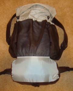 made myself from pattern. made myself from pattern.Comfortable, light, and plenty of room for all my gear. |
| Sleeping | |||
| shelter | 26 | $75 | 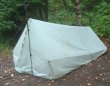 silnylon shelter I made, including stakes, lines, and groundsheet. Did not repel rain as expected, but otherwise has been great. I'll need to replace this before my next long trek. silnylon shelter I made, including stakes, lines, and groundsheet. Did not repel rain as expected, but otherwise has been great. I'll need to replace this before my next long trek. |
| sleeping quilt | 40 | $105 | 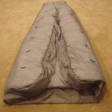 made myself from pattern. Really looking forward to sleeping in this again. made myself from pattern. Really looking forward to sleeping in this again. |
| Exped Synmat 7 UL Pad | 16.2 | $155 | 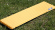 comfortable, warm, light mattress for restful nights. comfortable, warm, light mattress for restful nights. |
| Exped Schnozzel Pumpbag | 2.0 | $25.00 | 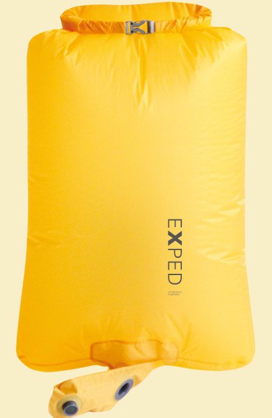 Fills pad quickly with dry cold air instead of hot moist breath. Serves as inflatable pillow and storage in pack for night clothes. Fills pad quickly with dry cold air instead of hot moist breath. Serves as inflatable pillow and storage in pack for night clothes. |
| Cooking | |||
| Snow Peak LiteMax stove | 2.0 | $45 | Since this is a short trek, I'm using a canister stove instead of alcohol. |
| Giga Power fuel | 7.0 | $5 | I'll only need to take one canister and it will get lighter every day. 4oz. fuel and 3oz. canister. |
| cook kit | 5.8 | $25 | includes spoon, pot, foil lid, stand, windscreen, and lighter. |
| food cozy | .8 |  insulates food package while the hot water is heating it up. Saves fuel and works super. insulates food package while the hot water is heating it up. Saves fuel and works super. | |
| food | 0-10lb. | . | |
| Water | |||
| water filter | 4.2 | $51.70 | Sawyer filter. Using 1L dirty water bag since 2L bag leaks now. 2nd bag leaked too, so now I'm down to .5L bag and will need to purchase new ones. |
| water bottles | 1.2 | two .6L throw-out bottles - cheap, easy, light. | |
| water bag | .9 | $8 | 1L Platypus roll-up, just for backup. |
| water | 1-4lb. | water is plentiful, so no need to carry much. 2.2lb/L | |
| Clothes | |||
| down coat | 21 | $120 | my only down item and I love it. |
| BSA t-shirt | 11.2 | $20 | light, synthetic - 2 shirts |
| arm warmers | 3.8 | $9 | 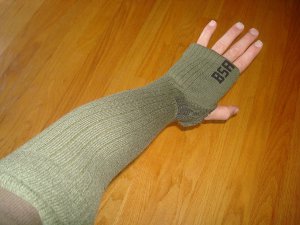 made from kneelength socks for chilly evenings and mornings, instead of long-sleeve shirt made from kneelength socks for chilly evenings and mornings, instead of long-sleeve shirt |
| gaiters | 1.5 | $19 | Dirty Girl gaiters. Didn't need them this time, just extra weight. |
| BSA zip-off pants | 17.2 | light and sturdy | |
| BSA socks | 5.7 | 3pr. hiking socks | |
| shoes | 32.5 | $60 | New Balance 606 - heavier than my previous two pair :-( but they are comfortable so far :-) |
| underwear | 4.2 | 2pr. | |
| BSA hat | 3.5 | baseball style | |
| bandanna | 1.0 | ||
| long underwear | 12.4 | top & bottom - did not use bottoms at all | |
| Electronics | |||
| cellphone | 4.3 |  borrowed, for daily blogs and pics. borrowed, for daily blogs and pics. | |
| camera | 5.4 | old digital SONY. forgot battery so only had cellphone pics half of trip. | |
| tracker | 5.1 | pings to satellite with my location. | |
| Other | |||
| pedometer | .6 | $25 | 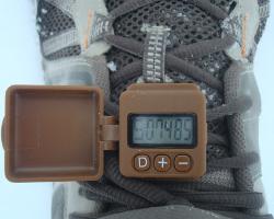 track my steps, just for fun track my steps, just for fun |
| rain poncho | 3.4 | $4 | cheap disposable to cover me and pack from rain - taking 2. Used 3 days just fine. |
| maps | 2 | $2.50 | poor set of 5 maps for entire trail. It's well-marked and maps aren't needed. |
| 1st aid kit | 2.3 | not used | |
| pad repair kit | .4 | not used | |
| compass | 1.1 | not used | |
| knife | 1.1 | tiny, single blade. not used | |
| toothbrush | 1.3 | includes paste | |
| ear plugs | 0 | not used | |
| 50ft. core | 1.5 | hanging food to protect from animals | |
| toilet kit | 2.8 | TP, Purell - campsites have pit toilets so no trowel | |
| trek poles | 19.4 | $30 | 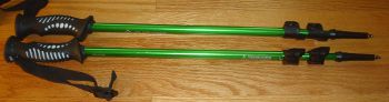 The tips are shot after AZT and SHT, but I'll get another few hundred miles from them. Use to support shelter also. The tips are shot after AZT and SHT, but I'll get another few hundred miles from them. Use to support shelter also. |
| headlamp | .5 | $11 | 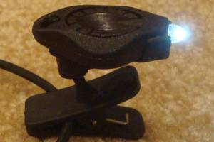 Awesome photon light, with spare batteries. One set of batteries lasted entire trip. Awesome photon light, with spare batteries. One set of batteries lasted entire trip. |
| Stick Pic | .4 | self-pictures and videos | |
| misc. | 2.8 | 2 garbage bags, whistle, clippers, thermometer | |
| Total | 18.5lbs 4lbs worn, not in pack 14.5lb pack weight 2 to 10lb food & water 17 to 27lb - total weight | ||
My Food
My daily menu was:
- Breakfast: 2 poptarts - 400 calories
- Snacks: granola, raisins, sunflower kernels, 2 Snickers - 1000 calories
- Dinner: Knorr noodles, salmon or tuna or chicken pouch, 1 oz. olive oil - 700 calories
- Drink: mostly water, gatorade - 100 calories
- Daily vitamin
I lost about 5 pounds over the two weeks.
My Expenses
The total trip cost. Towns are VERY expensive with hotels and restaurants so avoiding them helps keep costs down. Since this trail was so short, the travel to trail costs are high per mile of trail.
- gas for drive to trail and back - $140
- gear - $130 - shoes, shirt, pumpbag
- SHTA membership and maps - $42
- food - $80
- state park camping - $20 (1 nite, ouch!)
- Grand Marais hotel - $44
- gift for Duluth house - $22
- Duluth food - $18
- misc - $6
- Total - $500 - about $2/mile
$1.50/mile without gear.
Superior Hiking Trail Statistics
| States | Minnesota |
| Distance | 310 miles |
| Total Elevation | around 20,000feet. It's a fairly short trail with not a lot of high points, but lots of 100-500foot ups and downs. |
| Terminus | North: Otter Lake Road by Canadian border South: Jay Cooke State Park |
| Highest Point | Rosebush Ridge, 1829ft |
| Lowest Point | Lake Superior, 602ft |
| Map | 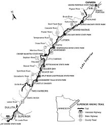 Click for Large Map |
| Terrain | There are no high elevations or long, steep climbs, but the trail follows the ins and outs and ups and downs of creeks running from the ridge into Lake Superior. This makes the trail fairly rugged and inclined much of the time. Extensive erosion due to no use of switchbacks has made much of the trail exposed roots and rocks so it's a tough tread. The trail is marked with blue blazes and prolific signage. It is a highly used trail with about 90 established campsites along its length. These sites must be used, but in the Superior National Forest dispersed camping is legal. |
| History | Started in mid-1980s. Superior Hiking Trail Association started in 1986. First thru-hiked by Paul Hlina in 1995. |
| Challenges |
Bears, wolves, moose, and other animals may be encountered. Sudden weather changes due to proximity to Lake Superior. |
| Time Window | April through October. Summer has humidity, mosquitos, and black flies. Late August through September are the best bet with October bringing cold and rain season. |
| Time to Hike | Typically takes 2 to 4 weeks. Speed record is 4 days set by Erik Kaitala in 2005, but that was when there was only 205 miles of trail. |
| Permits | There are no fees or permits required to hike the Superior Hiking Trail. |
| Thru-hiker Tally | No Idea. No records kept. |
Trail Links | |
| Agencies | Superior Hiking Trail Association |
All Comments:
Sep 12, 2012 - Laura Sheffield
Sep 13, 2012 - Hiking Dude
Sep 16, 2012 - Bryan Ebert
Oct 17, 2012 - Hiking Dude
Nov 03, 2012 - Papa Bear
Feb 01, 2013 - Take Two
Mar 25, 2013 - Alicia
Mar 26, 2013 - Hiking Dude
Aug 12, 2013 - Erik Schwebach
Mar 05, 2014 - Lowell
Mar 24, 2014 - Hiker Huey
Mar 24, 2014 - Hiking Dude
Mar 25, 2014 - Hiker Huey
Mar 25, 2014 - gene
Mar 25, 2014 - Hiking Dude
Aug 29, 2014 - Joe
Aug 29, 2014 - Hiking Dude
Aug 29, 2014 - Nobody
Aug 29, 2014 - Hiking Dude
Sep 14, 2014 - brian
Sep 14, 2014 - Hiking Dude
Dec 07, 2014 - Hanna
Dec 10, 2014 - Hiking Dude
Dec 15, 2014 - Keith
Apr 07, 2015 - Mike S
Apr 21, 2015 - Jen
Apr 21, 2015 - Hiking Dude
May 22, 2015 - Giselle
May 22, 2015 - Hiking Dude
Jul 07, 2015 - Peteo
Jul 19, 2015 - Hiking Dude
Jul 19, 2015 - michelle
Jul 30, 2015 - Julie
Jul 30, 2015 - Hiking Dude
Aug 19, 2015 - Katy
Nov 25, 2015 - Criss Henderson
Feb 03, 2016 - Sarah
Feb 03, 2016 - Hiking Dude
Mar 22, 2016 - Noah
Mar 23, 2016 - Hiking Dude
Going 45 miles from Penn to Caribou Wayside would be more doable, but it depends on you.
That chunk of trail includes Bear and Bean Lake overlooks, Sawbill Dome, Section 13, and some nice lake views and river crossings. 13 miles to Kennedy Creek first day, then 17 to Sonju Lake, then 14 to Caribou.
I've not used shuttles on the SHT, but everything I've heard is that it's very easy, as long as you have $$$.
Mar 25, 2016 - Lisa
Mar 28, 2016 - Hiking Dude
I'm lucky that I know people in Duluth and would have them pick me up for the night.
May 05, 2016 - Jeremy
May 13, 2016 - Peter Gausmann
Thanks!
Peter
May 13, 2016 - Hiking Dude
May 17, 2016 - Peter
Jun 18, 2016 - Matt
Thanks any and all info is greatly appreciated
Jun 26, 2016 - Hiking Dude
A person could hike the whole trail in 10 days and carry all the food needed from the starting point. Or, hike fewer miles each day, carry just 2 or 3 days and stop at most towns. It depends on individual goals and hiking styles.
Jul 08, 2016 - Josh
I am doing this the first week of august for around 3-4 days. Which part of the trail would you suggest?
And do you have any information on the shuttle service they provide?
Thank you!
Jul 08, 2016 - Hiking Dude
See shuttle PDF.
Aug 04, 2016 - Paul
Aug 04, 2016 - Hiking Dude
Aug 25, 2016 - Mike Shea
Aug 27, 2016 - Hiking Dude
Any 70 mile section of the SHT that you pick will have rugged and smooth, up and down, muddy and dry, brushy and open, and scenic and boring parts to it. The northern part is no more difficult than the south, just more remote and used less.
Rating the trail doesn't mean much from one person to the next. The SHT is rugged with steep climbs and descents, but they are hundreds of feet high, not thousands like on the AT.
Most people we met on trail were camping, not hiking miles. They did 5 to 10 miles in a day. I did 20-25 on my thru-hike.
Dec 17, 2016 - Pat Enright
Jan 22, 2017 - Barbie
Jan 26, 2017 - Hiking dude
As long as you have experience with your hanging system, things should be fine.
Apr 26, 2017 - Curt
Looking to go the last week in June for 4-5 days. Any recommendations on which part of the trail to hike. Also do you think bugs will be a problem?
Thanks for you input,
Curt
Apr 26, 2017 - Hiking Dude
You could stop 4 miles shorter at Sugar Loaf Road or add a tough 8 miles to the Crosby-Manitou parking lot.
There will be plenty of bugs.
Apr 28, 2017 - dean
Other than 4 back country campsites near Jay Cooke, I don't see any other spots to camp. Any suggestions on where to camp between Jay Cooke and Duluth?
Once in Duluth, what do you do? Are hotels best option?
Thanks
Dean
Apr 28, 2017 - Hiking Dude
It's about 60 miles from southern terminus to the first free SHT campsite. There is a campground at Spirit Mountain about 30 miles from southern terminus.

There is camping in Bagley on UMD campus about 21 miles north of Spirit Mountain and 9 miles south of first free campsite.
I's a good idea to check out Trail Conditions before your trek.
Jul 09, 2017 - Carrin
Jul 12, 2017 - Hiking Dude
Nov 07, 2017 - Julio
1. Are there outfitters in Duluth where I can get canisters for my gas stove? Gas canisters are not allowed in commercial flights and I need to buy one before I start the trail.
2. More importantly: once I arrive in Duluth, how do I get to the trailhead? I read in the webpage that one can start in Wild Valley Road and hike across Duluth, but there is no camping and hikers have to stay in hotels. I am not into that. I wish to have a real wilderness experience so I would like to begin my hike at Martin Road Trailhead. How far is that trailhead from Duluth and how do I get there?
3. What are the best towns to resupply? What is the mileage in between and how many resupplies do you recommend? I normally rely on mail drops but I would like to count on towns with a decent supermarket where I can buy something else that may appeal to me: sometimes I even ship things back home. Thank you for your answers.
Nov 07, 2017 - Hiking Dude
2. There are two places to camp in Duluth - Spirit Mountain and Bagley Nature Area on UMDuluth campus. How are you getting to Duluth? That ride can just drop you off right at the Martin Road trailhead, or you could take a taxi. Trailhead is just 8 miles from downtown Duluth waterfront or 7 miles from airport, and Walmart is just a couple miles from the airport for your gas.
3. The SHTA trail sections shows everything about the trail and mileage and camp spots. SHTA thru- hiking has links to mileages and resupplies. Number of resupplies depends on how fast you hike and how much you will carry. Starting at Martin Road, Silver Bay and Grand Marais are at about 100 and 200 miles up the trail.
Apr 25, 2018 - Margaret
Apr 25, 2018 - Hiking Dude
But, during summer months, it can be very overcrowded with campsites being overflowing with people.
May 29, 2018 - Stubs
Jul 02, 2018 - Mike
Ask a Question
Find more Hiking Resources at www.HikingDude.com
Follow Me
Recent Comments